Fort Kent is a small town in northern Maine’s Aroostook County, sitting right on the Canadian border where the Fish River meets the Saint John River. It marks the northern end of U.S. Route 1, the highway that runs all the way down to Key West, Florida.
That “America’s First Mile” monument draws plenty of visitors. The town offers more than just a photo stop.
Its French-speaking Acadian roots still shape daily life, from local food to family names.
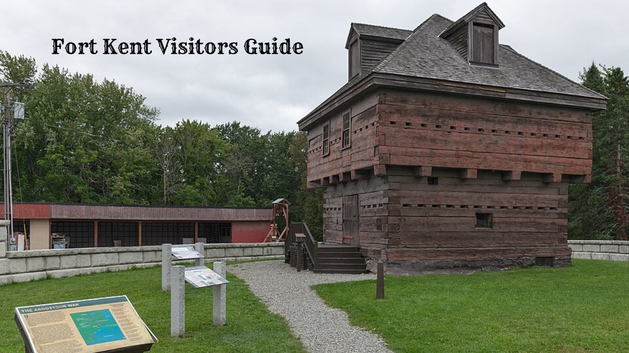
The Fort Kent Blockhouse, built during the Aroostook War border dispute in the late 1830s, still stands as a state historic site. Nearby, the Nordic Heritage Center trains world-class biathletes and hosts international competitions.
This Fort Kent travel guide covers what travelers can see and do in Fort Kent, Maine, including its history, outdoor recreation, and the small businesses that keep the town running year-round.
BOOK YOUR TRIP TO FORT KENT HERE
Fort Kent Visitor Information
Fort Kent sits at the northern end of U.S. Route 1 in Aroostook County, Maine. The town markets itself as “America’s First Mile,” and a monument near the bridge marks the spot where the highway begins.
Getting there: Most visitors drive north on Route 1 or take Route 11 from the south. The Fort Kent–Clair border crossing connects the town to New Brunswick, Canada, so travelers should carry a passport or other approved documents.
Fort Kent State Historic Site protects the blockhouse built during the Aroostook War border dispute of the late 1830s. The site covers about three acres along the Fish River, near where it meets the St. John River.
| Detail | Information |
|---|---|
| Location | Block House Road, Fort Kent |
| Size | About 3 acres |
| Season | Late spring through early fall |
| Admission | Free |
| Features | Historic blockhouse, picnic area, river access |
The blockhouse is usually open during daylight hours in summer. Hours can change from year to year, so calling ahead or checking with the Maine Bureau of Parks and Lands is a good idea.
Planning tips:
- The Greater Fort Kent Area Chamber of Commerce offers visitor guides covering the St. John Valley.
- An RV and tenting park operates in town for travelers who camp.
- French and English are both spoken widely in the valley.
Winter visitors should prepare for cold temperatures and heavy snow. Summer brings mild weather and longer daylight hours for hiking and paddling.
BOOK YOUR TRIP TO FORT KENT HERE
History of Fort Kent
Fort Kent began as a military post during a border dispute between Maine and New Brunswick, Canada. That dispute is known as the Aroostook War, though no battles were ever fought.
A Maine civil posse built the fort in 1839. Workers chose a rise of land where the Fish River meets the Saint John River.
The main structure was a two-story blockhouse made of hand-hewn cedar logs. Barracks and officers’ quarters stood nearby.
U.S. Army troops took over the post in 1841 and expanded it. They left in 1843.
The Webster-Ashburton Treaty of 1842 set the boundary between Maine and Canada. Once the border was settled, the fort no longer had a purpose, and soldiers were withdrawn.
Here is a quick look at the key dates:
| Year | Event |
|---|---|
| 1839 | Fort built by a Maine civil posse |
| 1841 | U.S. Army troops take over and expand the post |
| 1842 | Webster-Ashburton Treaty settles the border |
| 1843 | Army abandons the fort |
| 1869 | Town of Fort Kent incorporated |
| 1891 | State of Maine buys the site |
| 1969 | Added to the National Register of Historic Places |
| 1973 | Named a National Historic Landmark |
The property passed into private hands after the troops left. Maine purchased it in 1891 with plans to save it, but real preservation work did not start until 1959.
The blockhouse is the only building left from the original fort. It’s also the only surviving American fortification from the Aroostook War.
What to See
The Fort Kent State Historic Site sits at the meeting point of the Fish River and the St. John River. A hand-hewn log blockhouse from 1839 still stands here.
Visitors will find military artifacts, historical markers about the Aroostook War, riverfront views, and open lawns for picnicking.
The Historic Blockhouse
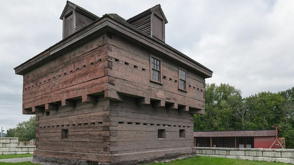
The Fort Kent Blockhouse is the main attraction. It was built in 1839 during the Aroostook War, a border dispute between the United States and Britain that ended without a single battle.
The two-story structure is made of squared cedar logs. Its second floor overhangs the first, a defensive design that let soldiers fire down on anyone at the base of the walls.
This blockhouse is the only surviving fortification tied directly to that conflict. It became a National Historic Landmark in 1973.
Inside, the low ceilings, narrow gun ports, and thick timber walls give a clear sense of how cramped life was for the militia stationed there.
Museum Exhibits and Artifacts
The blockhouse doubles as a small museum. Displays are managed with help from the Boy Scouts and local volunteers, and admission is free.
Exhibits inside focus on a few main themes:
- Aroostook War history — maps and documents explaining the boundary dispute and the 1842 Webster-Ashburton Treaty that settled it
- Military items — muskets, tools, and equipment used by Maine militia units
- Logging heritage — hand tools and photographs from the river drive era, when timber moved down the St. John
- Local settlement — items connected to the Acadian and French-Canadian families who built the surrounding community
The collection is modest in size. Most visitors spend 20 to 40 minutes walking through both floors.
Interpretive Signs and Historic Markers
Panels placed around the grounds explain what happened here and why it mattered. They cover the timeline of the 1838-1839 standoff, the role of Maine’s militia, and the negotiations that fixed the border along the St. John River.
One marker identifies the site’s National Historic Landmark status. Others point out the fort’s original layout, which once included barracks and other buildings that no longer stand.
The signs use plain language and include reproductions of period maps. Readers can follow the story without a guide, though staff is often on hand during summer hours.
Fish River and St. John River Setting
The site is where the Fish River empties into the St. John. That location was chosen on purpose in 1839 — it let troops watch both waterways and the traffic moving on them.
The St. John River forms the international boundary here. Canada sits directly across the water, and the New Brunswick shoreline is visible from the grounds.
The Fish River is also where anglers chase muskellunge, the large predatory fish that draws people to the annual Fort Kent International Muskie Derby.
Nearby, the Fort Kent Riverside Trail System runs along both rivers. It connects the historic site to walking paths, a levee, and several small parks.
Park Grounds and Picnic Areas
The grounds around the blockhouse are open lawn with mature shade trees. Picnic tables are available, and there is no fee to use them.
The site is a short walk from downtown Fort Kent and close to the northern terminus of U.S. Route 1, marked by the “America’s First Mile” monument.
A few practical notes:
| Detail | Information |
|---|---|
| Admission | Free |
| Blockhouse season | Typically Memorial Day through Labor Day |
| Grounds access | Open year-round during daylight |
| Parking | On-site, no charge |
The lawn also serves as a launch point for the Northern Forest Canoe Trail. That 740-mile paddling route ends in Fort Kent.
Things to Do at the State Historic Site
Fort Kent State Historic Site sits on about three acres where the Fish River meets the St. John River. The main attraction is the blockhouse, a two-story building made of square-hewn cedar logs, some more than 19 inches wide.
Visitors can walk through both floors of the blockhouse, which now serves as a small museum. Displays cover the Aroostook War of 1838–1839, the border dispute between the United States and Great Britain, and daily life for the troops stationed here.
Things visitors can do on site:
- Tour the blockhouse museum, the only surviving fortification tied to the Aroostook War
- Read the interpretive signs about the boundary dispute and the 1842 Webster-Ashburton Treaty
- Take photos at the meeting point of the two rivers
- Use the grounds for a picnic or a short walk
- Stop at the nearby northern end of U.S. Route 1
| Detail | Information |
|---|---|
| Season | Memorial Day through Labor Day |
| Hours | 9 a.m. to 5 p.m. daily |
| Admission | Free; donations accepted |
| Location | Fort Kent, Aroostook County, Maine |
Local Eagle Scouts help maintain the blockhouse in cooperation with the state.
Most people spend under an hour here. Many pair the visit with a stop at the Fort Kent Historical Society, which keeps several buildings of local artifacts, including the 1902 railroad station.
Is It Worth Visiting?
Fort Kent’s a good fit for travelers who want quiet scenery, outdoor adventure, and a strong local culture. If you’re looking for crowds, nightlife, or big attractions, this isn’t the spot.
The town sits at the northern tip of U.S. Route 1, right where the St. John River meets the Canadian border. A lot of folks stop here just to say they made it to the end of the road.
Reasons people find the trip worthwhile:
- Easy access to the St. John River for paddling and fishing
- Snowmobile and cross-country ski trails in winter
- The Can-Am Crown International Sled Dog Races every March
- Acadian and French-Canadian heritage—think local food, language, and culture
- The Fort Kent Blockhouse and the historical society museum
Things to consider before going:
- It’s a long drive from Portland or Bangor, and services are pretty limited along the way
- Lodging options are few—just a handful of hotels, inns, and campgrounds
- Restaurants and shops are small in number
- Winter weather gets rough, and roads sometimes close
Is Fort Kent worth visiting? If you’re a hiker, paddler, snowmobiler, or you’re into Acadian history, it’s a yes. If you want museums, theaters, or lots of dining options, southern Maine might suit you better.
Families usually find enough to do for a couple of days, especially in summer and early fall. If you plan your visit around something like the sled dog races or peak fall foliage, you’ll probably get the most out of it.
Tips for Visiting
Fort Kent sits way up at the top of Maine, so expect a long drive. From Bangor, it’s about four hours via Route 11 or I-95 and Route 1.
When to go
- Winter (December–March): Best for snowmobiling, skiing, and the Can-Am Crown Sled Dog Races in early March.
- Summer (June–August): Good for fishing, paddling the St. John River, and biking.
- Fall (September–October): Cooler weather and great fall colors along the river valley.
If you want to cross into Canada, you’ll need a passport or approved travel document. The border station connects Fort Kent to Clair, New Brunswick, and it’s open all year.
A few practical notes:
| Topic | What to Know |
|---|---|
| Lodging | Not many options. Book early for race weekend or hunting season. |
| Language | Lots of folks speak both French and English. |
| Cell service | Reception drops outside town, so download maps before you go. |
| Fuel | Gas stations are spread out. Fill up in town before heading out. |
Winter temperatures often drop below zero, and snow can stick around into April. You’ll want warm layers, boots, and a winter emergency kit in your car if you’re visiting in the cold months.
Always check trail conditions before heading out. The Maine Snowmobile Association and local clubs post updates on grooming and closures.
Most shops and restaurants are on Main Street, so the downtown’s easy to explore on foot.
Nearby Attractions
Fort Kent sits at the top of Aroostook County, and nearby towns are pretty spread out. Expect to drive anywhere from one to four hours to reach some of these spots.
Within a short drive:
- Allagash – About 25 minutes west. This tiny town marks the start of the Allagash Wilderness Waterway, a 92-mile canoe route ending at Chamberlain Lake.
- St. Francis and St. John – Riverside communities along Route 161 with river access and peaceful views.
- Eagle Lake and Wallagrass – South on Route 11, both offer lake access and snowmobile trail connections.
Across the border: Clair, New Brunswick, sits just across the St. John River. Saint-François-de-Madawaska is a short drive east. You’ll need a passport or travel document to cross.
Farther south:
| Destination | Approximate drive | What to expect |
|---|---|---|
| Madawaska | 25 minutes | Acadian heritage sites and the Four Corners Park |
| Van Buren | 1 hour | Acadian Village, a collection of restored buildings |
| Presque Isle | 2 hours | Shopping, an airport, and Aroostook State Park |
| Baxter State Park | 3.5 hours | Mount Katahdin and backcountry hiking |
Note: Cell service drops out on many northern Maine roads. Download maps ahead of time and fill your tank before heading out.
The North Maine Woods region starts just west of Fort Kent. You’ll hit checkpoints and pay fees to enter, and most roads are unpaved logging routes.
Frequently Asked Questions
Fort Kent sits at the northern tip of Maine, where the Fish River meets the Saint John River across from New Brunswick, Canada.
People often ask about the town’s name, its Acadian roots, the French-speaking community, and what you can actually do here with a population around 4,000.
Is Fort Kent a military base?
Nope. Fort Kent is a town, not an active military post.
The name comes from a wooden blockhouse built in 1839 during the Aroostook War, a border dispute between Maine and New Brunswick. They named the fort after Edward Kent, who was Maine’s governor back then.
The blockhouse still stands as part of the Fort Kent State Historic Site, a small spot near the river. No soldiers here now—it’s just for visitors and history buffs.
What is Fort Kent known for?
People know Fort Kent for three main things: Acadian culture, winter sports, and its spot at the top of U.S. Route 1.
The town marks the northern end of Route 1, which stretches all the way down to Key West, Florida. There’s a sign by the bridge to Canada marking the spot, and the area’s often called “America’s First Mile.”
Fort Kent also hosts the 10th Mountain Ski Center, a biathlon and cross-country skiing venue that’s seen some World Cup action. It’s one of the few places in the U.S. with regular international biathlon events.
Each March, the Can-Am Crown International Sled Dog Races finish here, including a 250-mile race.
Is Fort Kent worth visiting?
Depends what you’re after. Fort Kent is remote—about five hours north of Portland by car—and you won’t find big hotels or shopping centers.
If you love the outdoors, it’s rewarding. There’s snowmobiling on a huge trail network, fishing on the Fish River lakes, canoeing, hunting, and skiing.
If you’re interested in French-Canadian and Acadian heritage, there’s a lot to explore. Plus, it’s quieter and more affordable than Maine’s coast.
Do people in Fort Kent speak French?
Yes, a lot do. Fort Kent sits in the St. John Valley, where many residents have Acadian or French-Canadian roots.
French is still spoken at home and in some businesses, though fewer people use it every day now. The local dialect—Valley French—differs from the French taught in schools.
The University of Maine at Fort Kent supports bilingual programs and Acadian studies. You’ll probably hear both French and English in shops and restaurants.
What is the history of Fort Kent?
Acadian settlers came to the St. John Valley in the late 1700s, after the British expelled them from Nova Scotia. They built farms along the river, and their descendants still make up much of the population.
In 1839, they built the blockhouse when Maine and New Brunswick both claimed the land. The Webster-Ashburton Treaty in 1842 finally settled the border and put Fort Kent on the U.S. side.
The town was incorporated in 1869. Farming—especially potatoes—and the timber industry have long driven the local economy, and both still matter here.
What are the main attractions in Fort Kent?
| Attraction | What to expect |
|---|---|
| Fort Kent State Historic Site | The 1839 blockhouse and a small museum |
| Northern end of U.S. Route 1 | A marker and photo spot near the international bridge |
| 10th Mountain Ski Center | Biathlon range, cross-country trails, and events |
| Fish River Falls | A waterfall with a short hiking trail |
| Fort Kent Historical Society | Local artifacts housed in a former railroad station |
The town sits at the center of the Interconnected Trail System. Snowmobile routes wind across northern Maine from here.
Once the snow melts, ATV riders take over those same trails. It’s a pretty big draw for outdoor fans.
The University of Maine at Fort Kent campus puts on concerts, lectures, and sporting events. Most of these are open to the public, so it’s worth checking the calendar if you’re in town.

Cory is a website owner and content creator who enjoys fishing, history, coin collecting, and sports, among other hobbies. He is a husband and father of four.
Romans 15:4 For whatever was written in former days was written for our instruction, that through endurance and through the encouragement of the Scriptures we might have hope.