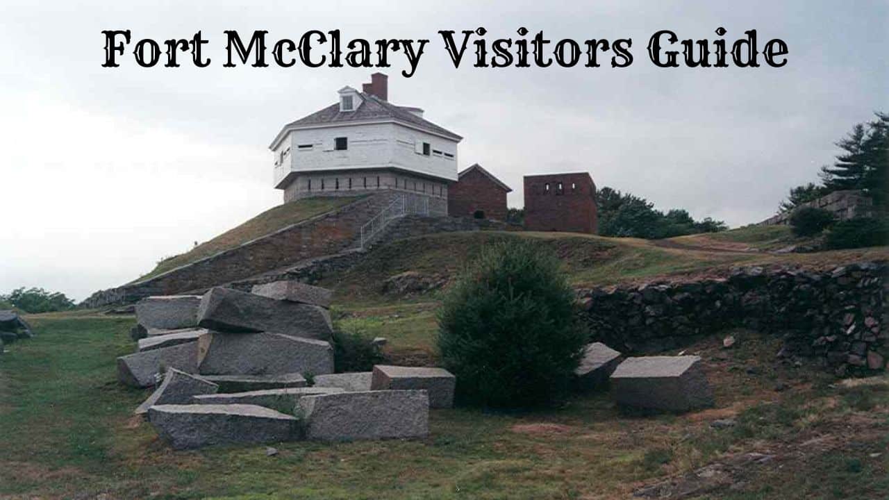
Fort McClary is a state historic site in Kittery Point, Maine. A hexagonal blockhouse, granite walls, and old cannons overlook the mouth of the Piscataqua River from here.
This land has served as a defense since the late 1600s.
Soldiers served here during five wars: the Revolutionary War, War of 1812, Civil War, Spanish-American War, and World War I. The fort’s name honors Andrew McClary, a New Hampshire officer who died at Bunker Hill.
Visitors today find more than old stone. The grounds feature a rifleman’s house, powder magazine, granite blockhouse, and harbor views with two lighthouses in the distance.
This guide covers the site’s history, what’s there now, and practical tips like parking, hours, and when to visit.
BOOK YOUR TRIP TO FORT McCLARY HERE
Fort McClary Visitor Information
Fort McClary State Historic Site sits along Route 103 in Kittery Point, Maine. The 27-acre property looks out over the mouth of the Piscataqua River and Portsmouth Harbor.
Getting there: The fort is just a few minutes’ drive from Route 1 and Interstate 95. There’s on-site parking, but the lot is small and fills up fast on summer weekends.
Hours and admission: The site is usually open daily from late May through early October. Visitors pay a small entrance fee at a self-serve station.
Fees are lower for Maine residents, seniors, and kids. Rates and dates sometimes change, so it’s smart to check with the Maine Bureau of Parks and Lands before heading over.
What visitors can see and do:
- The 1844 granite and timber blockhouse
- Granite walls, earthworks, and old cannons
- Foundations of the rifleman’s house and magazine
- Picnic tables with water views
- Views of nearby lighthouses across the harbor
There are grassy areas and rocky shoreline. Some paths are uneven, so sturdy shoes are helpful.
| Detail | Information |
|---|---|
| Location | Kittery Point, York County, Maine |
| Size | About 27 acres |
| Season | Late spring through early fall |
| Admission | Small fee, self-serve |
| Restrooms | Available in season |
The Friends of Fort McClary organize living history events and programs during the open season. They post the schedule online and at the site.
Pets are welcome on a leash. The fort is also a favorite spot for photography.
BOOK YOUR TRIP TO FORT McCLARY HERE
The History of Fort McClary
The land beneath Fort McClary has served a military purpose since 1689. That year, merchant William Pepperrell bought a plot called “Battery Pasture.”
The first defenses were basic. Soldiers built earthworks and a small blockhouse to watch the river mouth.
This spot guarded the entrance to Portsmouth Harbor, which was a busy and important port in early New England.
The fort’s name comes from Major Andrew McClary, a New Hampshire officer killed at the Battle of Bunker Hill in 1775.
Over time, people rebuilt and expanded the site several times. Soldiers were stationed here during these conflicts:
| Conflict | Approximate Period |
|---|---|
| American Revolution | 1775–1783 |
| War of 1812 | 1812–1815 |
| Civil War | 1861–1865 |
| Spanish-American War | 1898 |
| World War I | 1917–1918 |
The most recognizable building is the granite-and-wood blockhouse from 1844. You can still walk through it.
During the Civil War, a major rebuilding effort started in the 1860s. Congress cut funding before the new batteries were finished, so unused granite blocks still sit on the property.
The fort was last used in 1918. It never fired on an enemy ship, but it stayed active as a defensive post for nearly 200 years.
What to See at Fort McClary
The 27-acre site mixes standing buildings, stone ruins, and open lawn above the water. You can walk through a wooden blockhouse from the 1840s, trace unfinished granite walls, and read markers about the fort’s changes over five wars.
The Hexagonal Blockhouse
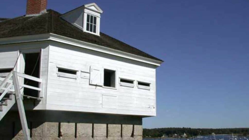
The blockhouse is what most people come to see. Built in 1844, it sits on a granite base, with a heavy timber upper floor that juts past the walls below.
The overhang is a machicolation. Soldiers could fire down through openings at anyone reaching the base.
The shape stands out. The foundation has six sides, making it one of the few surviving hexagonal blockhouses in the U.S.
Inside, you can check out thick hewn logs and narrow gun ports cut into the walls. The upper level is open during the season, and the old wooden floors and beams really show their age.
Granite Walls and Unfinished Fortifications
Much of the fort was never finished. Construction started in the 1840s and picked up again during the Civil War, but Congress pulled the plug before new gun batteries could be completed.
The result? A site full of half-built stonework. Large granite blocks sit stacked in rows, still waiting to be placed after more than 150 years.
Walk along the earthworks and you’ll see:
- The granite curtain wall, several feet thick, facing the river
- Gun emplacements with no guns ever mounted
- Loose cut stone left on the ground by 1860s crews
- Earthen ramparts from earlier construction
The unfinished sections make it easy to picture the building process.
Rifleman’s House and Powder Magazine
Two smaller stone buildings survive near the blockhouse. Both date to the mid-1800s.
The rifleman’s house is a low granite structure that once gave soldiers a covered firing spot. Its walls have narrow slots for rifle fire.
The powder magazine stored gunpowder and ammo. Thick walls and a heavy roof were meant to contain any blast and keep things dry.
Both buildings are modest and simple. Standing next to them, you get a sense of how little space a small garrison really needed.
Piscataqua River and Harbor Views
The fort sits right at the mouth of the Piscataqua River. That’s why they picked the site in the first place.
The view covers the shipping channel between Kittery Point, Maine, and New Castle, New Hampshire. Two lighthouses are visible from the grounds on a clear day.
Portsmouth Harbor Light stands across the water, and Whaleback Light marks the river mouth farther out. The lawn slopes down toward the shoreline, with picnic tables among the ruins.
Many folks spend as much time watching boats as they do exploring the buildings. At low tide, rocks and tide pools appear along the edge.
Interpretive Signs and Historic Markers
Signs around the grounds explain what each structure was for and when it was built. They cover the fort’s role in the Revolutionary War, the War of 1812, the Civil War, the Spanish-American War, and World War I.
One marker tells the story behind the name. The fort honors Major Andrew McClary of New Hampshire, who died at Bunker Hill in June 1775.
Other panels talk about how coastal defense changed over time, from earthworks and cannon to the heavier guns of the late 1800s.
The Friends of Fort McClary support the site and run living history events in season. Sometimes they add costumed demonstrations to the displays.
Things to Do at Fort McClary State Historic Site
People come to this spot in Kittery Point for two big reasons: the historic structures and the water views.
The hexagonal blockhouse is the star. Built in 1844 on a granite base, it’s one of the last standing blockhouses of its kind in Maine. You can step inside and look out through gun ports toward the river.
Other things to check out:
- The powder magazine, built in 1808 to hold gunpowder
- The rifleman’s house, a small granite building by the shore
- Earthworks and granite walls from the unfinished 1860s work
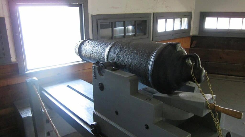
- Cannons positioned on the grounds
A short 0.4-mile walking trail loops through the property and connects most of these features. The path is easy and works well for families.
The picnic area sits on a grassy slope above the water. Tables and grills are available, and the view overlooks the river and Portsmouth Harbor.
Photographers love the wide harbor views, passing boats, and distant lighthouses.
In summer, you might catch living history events hosted by the Friends of Fort McClary. These programs bring costumed interpreters and demonstrations about the soldiers who served here.
The site is generally open from late May through early October. There’s a small entrance fee and no staffed visitor center, so plan ahead.
Is Fort McClary Worth Visiting?
If you’re passing through southern Maine, Fort McClary packs a lot into a small space. The site covers about 27 acres in Kittery Point, and most folks can walk the grounds in under an hour.
The big draw is the hexagonal blockhouse from 1844. It’s an unusual fort structure for New England, and you can step inside it.
Granite walls, earthworks, old cannons, and the foundations of unfinished buildings surround the blockhouse. The fort saw action during five wars, so there’s real history here.
The location is hard to beat. The fort sits at the mouth of the Piscataqua River, with views toward Portsmouth Harbor and two lighthouses.
Here’s who tends to enjoy it most:
| Visitor Type | Why It Works |
|---|---|
| History fans | Five wars of military use, plus a rare surviving blockhouse |
| Families | Open lawns, short walks, low admission fee |
| Photographers | Waterfront views and granite structures |
| Picnickers | Tables and shoreline access on site |
A few things to keep in mind: there’s no full museum, and the fort is seasonal, so hours are limited outside the warmer months.
Some paths are uneven, which can make walking tricky for some visitors.
If you’re already in the Kittery area, it’s an easy and worthwhile stop. If you want a full-day outing, maybe pair it with a visit to nearby beaches or Portsmouth.
Tips for Visiting Fort McClary
Fort McClary sits right on Route 103 in Kittery Point, just about 2.5 miles from Route 1 and the Maine Turnpike. Before you go, it’s smart to check the official state park website—hours and entrance fees shift with the season.
The site usually opens from late spring through early fall. If you show up off-season, you’ll probably find the grounds open, but the buildings locked tight.
What to bring:
- Sturdy shoes for uneven ground and stone steps
- A camera for those views of the Piscataqua River and two distant lighthouses
- Water and snacks, since there’s nowhere to buy food on site
- A jacket or windbreaker—trust me, the shoreline gets breezy fast
The 27-acre property holds the granite blockhouse, earthworks, old foundations, and some pretty hefty cannons. Walking paths connect everything, but watch your step—some spots have loose footing and low walls.
If you’ve got little kids with you, keep them close near the water and those sudden drop-offs along the granite walls.
| Tip | Why It Helps |
|---|---|
| Arrive early or late in the day | Smaller crowds and better light for photos |
| Allow one to two hours | Enough time to explore the grounds without rushing |
| Look for living history events | Reenactors and demonstrations add context to the site |
| Combine with nearby stops | Pepperrell Cove and Kittery shops are minutes away |
Parking is limited, and busy summer weekends can fill the lot quickly. Restrooms are seasonal, and pets are usually welcome as long as they’re leashed.
Benches by the water are perfect for taking a break and watching boats slip through the harbor.
Nearby Attractions
Fort McClary sits in Kittery Point, close to several other spots worth checking out. Most are a quick drive, and a couple is even walkable if you’re feeling ambitious.
Pepperrell Cove is right next door. You’ll get water views, a few places to eat, and an easy spot for a picnic or quick photos.
Fort Foster lies about four miles away on Gerrish Island. The park has beaches, walking trails, and some pretty great views of the harbor and lighthouses.
Across the river in New Hampshire, you’ll find more historic sites:
| Attraction | Location | What to Expect |
|---|---|---|
| Fort Constitution | New Castle, NH | Colonial-era fort and harbor views |
| Portsmouth Harbor Lighthouse | New Castle, NH | Working lighthouse with seasonal tours |
| USS Albacore | Portsmouth, NH | A retired Navy submarine open to the public |
| John Paul Jones House | Portsmouth, NH | 1758 home and museum |
In York, the Wiggly Bridge claims to be one of the smallest suspension bridges in the country. It connects to a short trail through Steedman Woods.
Downtown Portsmouth is just a 10-minute drive. The walkable district is packed with shops, restaurants, and the African Burying Ground Memorial Park.
Local tip: Kittery’s outlet stores line Route 1, so it’s easy to swing by on your way in or out of town.
There are also several breweries and ice cream shops nearby, including Side by Each Brewing Co. Hours can change with the season, so it’s worth calling ahead.
Frequently Asked Questions
Fort McClary sits right on the Piscataqua River in Kittery Point, Maine. Its 1846 hexagonal blockhouse is what draws most people in.
People often ask about the fort’s military history, when the park’s open, how to get there on Route 103, and where to find good coastal walks.
What is the history of Fort McClary?
The site has guarded the mouth of the Piscataqua River since the early 1700s. Colonists first fortified the point to protect ships heading to and from Portsmouth Harbor.
The fort is named for Major Andrew McClary, a New Hampshire officer killed at the Battle of Bunker Hill in 1775.
Work at the fort continued through the American Revolution, the War of 1812, and the Civil War. Crews even made improvements during the Spanish-American War.
The hexagonal granite-and-wood blockhouse was built in 1846. It’s one of the few blockhouses of its kind still standing in the U.S.
Much of the later granite construction was never finished. You’ll still see cut stone blocks scattered around where workers left them.
What can visitors see and do at the state historic site?
The blockhouse is the star, and you can step inside to see its heavy timber framing and gun ports.
Other features on the roughly 27-acre property include:
- The 1808 rifleman’s house and a powder magazine
- Sections of granite walls and earthworks
- Stacks of unused cut granite blocks from unfinished 1860s work
- Open lawn with picnic tables and river views
The rocky shoreline below the fort draws birdwatchers. You’ll often spot eiders, cormorants, and even harbor seals along this stretch of coast.
Living history events and educational programs pop up during the warmer months, thanks to the Friends of Fort McClary.
What are the opening hours and seasonal dates?
The historic site generally opens from late May through the end of September. Some years it’s around Memorial Day weekend, closing on October 1.
Daily hours usually run from 9 a.m. to sunset while the park’s open.
A small admission fee applies, with lower rates for Maine residents, seniors, and kids. You’ll pay at a self-service station.
Sometimes you can access the grounds outside of the official season, but buildings stay closed, and no staff is around. Checking the Maine Bureau of Parks and Lands website before you go is your best bet for up-to-date hours and prices.
Where is the site located, and how can I get there?
Fort McClary is at Kittery Point, Maine, on Route 103, about two and a half miles east of the Route 1 bridge in Kittery.
If you’re coming from Interstate 95, take the Kittery exits, follow Route 1, then turn onto Route 103 and keep heading east along the shore.
The fort is just a short drive from the Kittery outlets and about ten minutes from downtown Portsmouth, New Hampshire.
Parking’s available in a lot across the road from the fort and in a smaller area right near the entrance. Spaces fill up fast on summer weekends.
Are there walking trails or beach access nearby?
The fort grounds have short, informal paths winding around the blockhouse, along the earthworks, and down toward the rocky water’s edge. These are more like walking paths than a formal trail system.
The shoreline’s rocky, not sandy. Wear sturdy shoes and watch out for slippery seaweed near the tide line.
If you want a sand beach, Seapoint Beach and Crescent Beach are a few miles east on Route 103 in Kittery Point, but parking there is mostly for residents during the summer.
The Brave Boat Harbor section of the Rachel Carson National Wildlife Refuge is also nearby and has a marked trail through salt marsh and woods.
What is the largest fort in Maine?
Fort Knox, in Prospect, stands as the largest historic fort in the state. It sits above the Penobscot River, right by the Penobscot Narrows Bridge.
They started building Fort Knox in 1844 and didn’t finish until 1869. The fort’s made from granite and has winding underground passages and gun batteries.
Two full granite batteries face out over the river. You can almost imagine the echoes down there.
Fort McClary? That’s quite a bit smaller. People seem to like it mostly for its old blockhouse and the stories that linger, not for its size.

Cory is a website owner and content creator who enjoys fishing, history, coin collecting, and sports, among other hobbies. He is a husband and father of four.
Romans 15:4 For whatever was written in former days was written for our instruction, that through endurance and through the encouragement of the Scriptures we might have hope.